
Studies and research has been done on variuos heritage properties in Jharkhand. Some of them are listed below:
Old Birsa Munda Jail
 |
Built in the mid-nineteenth century by the Britishers, the historical significance of the jail lies in the fact that Bhagwan Birsa Munda, whose life history goes down in the history of Jharkhand as a stor y of emancipation of his own people who were subjected to prolonged suppression by the Britishers, was incarcerated here. He died at the tender age of 25 years in mysterious circumstances in the jail on 9th June, 1900. The jail was later renamed Birsa Munda Central Jail. |
Tagore Hill
 |
Tagore Hill, associated with the noted Theater personality. Jyotirindra Nath Tagore, elder brother of Rabindra Nath Tagore, the noble laureate, is located 3 kms from Ranchi GPO on a nearly 300 ft high hill. Local people and visitors to Ranchi town visit this place regularly to see the beauty of the town from the greater height. In the middle of the hills, their is ' SHANTI BHAWAN' in which Jyotirindra Nath Tagore had lived and finally died. A lone structure on the Tagore Hill top namely 'Brahm Sthal' measuring 3mX3m is the tanding tall on the hillock. It is in a critical condition. The pillars, conical dome and ceiling have cracked; the outer portion of the structure has extensive weeding which has been damaging it badly. The structure has worn out at various locations both inside and outside. |
Audrey House
 |
Audrey House is situated at R a j B h a v a n premises, Ranchi. It is more than 150 years (1855-56)old. It was used as a residence of British Officers. It is made of wood and steel structure with slanting roof fitted with tiles, two of its main hall has wooden flooringwhich adds to its beauty & grandeur. |
Rajmahal
 |
Geographically on one side of the Rajmahal River Ganges is flowing and on the other side it is surrounded by mighty mountain ranges. It had gone through many ups and downs in its very existence. Its past had been embedded with glory and now the region is lying in oblivion. Its history dates back to mid 15th century. It's also believed that Rajput clan lead by Raja Udai Singhhad also their presence in this area, when King Shashank had shifted his capital from Gaur in Malda (W.B) to Rajmahal. Udai nala (now Udhawa Nala) flowing eight kilometers east of Rajmahal was the place where LordClive caught Nawab Sirajjudaula while crossing nala. This place came into lime light during 1580 / 1595 during Mughal regime when Emperor Akbar made Raja ManSingh the Subedar of Bengal Region who had made Rajmahal its headquarters. He used to control entire Bengal, Orissa, Assam & Bihar from here. |
Navratangarh
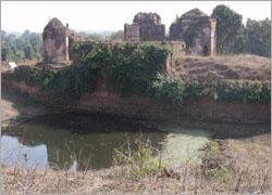 |
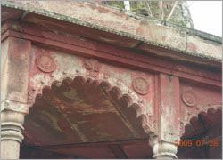
A part of Doisa Nagar, it is situated in the Sisai block of Gumla district. It was the palace of Nagvanshi rulers and was a five storied building with nine rooms in each floors, hence christened as Navratangarh. The three floors of the building is found above the ground level and it is said that two storied had been buried below. It has the touch of Mughal architecture and the woods and carvings within the building are very attractive. There are several temples built around the main building. As per available information this palace was built by King Raghunath Sahi during 18th century. It is also said that King Durjan Sal had built this palace, who after getting released from Gwalior fort, had built it on his return. It is the only remains of Nagvanshi regime that can be seen and once restored to its glory will be a major tourist destination |
Hazaribagh
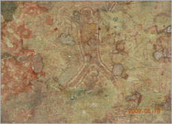 |
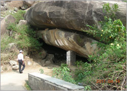
Isko village is located 45 kms under Barkagaon block to the south east from Hazaribagh district headquarter. Discovery of rock paintings dating back to the mid stone age as per archaeological estimate, has confirmed that ancient civilisation had once thrived in the rocky plains of the Jharkhand region wedged between the mighty Damodar River and the hills of Chotanagpur plateau. Tests carried out by experts have recorded that while the rock painting are around 10,000 years old, the cave paintings discovered from the hills of Isko village date back to the mid stone age period more than 30,000 years ago. Engraved in the huge boulders are carvings depicting gods and goddesses, men and women, domestic animals and some species of wild animals particularly deer. |
Itkhori (Chatra )
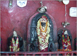 |
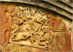
Itkhori, a block headquarter within Chatra district. Itkhori lies north of Hazaribagh, about 16 kms west of Chouparan to be more precise. It is a wonderful place with abundance of historic reminiscences and a r c h a e o l o g i c a l r e m n a n t s demonstrating a breathtaking saga of religious tolerance and cultural unity. More than 1200 years ago the great Pala and Gupta emperors looked out from the terrace of the magnificent Maa Bhadrakali temple complex built during 9th Century. The workmanship of the images and statues indicate a highly developed heritage of skills in the finer arts. And if wonders were to follow wonders, the Shiva-linga in the adjacent temple hano less than 1008 'lingams' carved into its surface. Images of 104 Bodhisattvas and 4 principal Buddhas are sculpted on each side of a 'stupa'-like structure. Close by is a stone slab with foot-impressions on its surface - believed to be that of Sheetalnath, the 10th Tirthankara of the Jain religion. |
Tanginath
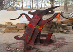 |
It is a historical place situated in remote Dumri block of the district as worship is done here by traditional tribal Baiga priests and numerous 'shivlingas' and images of gods are spread at the temple premises. Trishul and other findings are centuries old. Tanginath is synonymous to Lord Shiva as people have been worshiping Him since ancient days, says a member of Tanginathdam Vikas Samiti. Tanginath is a place having several architectural works in its lap since the ancient era to the medieval era . It is famous as SHIVASTHALI and is famous for great TRISHOOL of rustproof iron TANGINATH lies in Dumri block in Gumla district |
Maluti (Dumka)
 |
In 1855, after the revolt lead by Sidhu Kanhu in Santhal area, the Santhal Paragna district was created. It was the time when 'Maluti' was taken as a part of the newly created district taking Chandannala River as the natural boundary for the division. It was derived out of the Birbhum district of West Bengal. Now this village is situated in Dumka district of Santhal Paragna Division of Jharkhand. Bangla is still the common language here but some of the villagers do communicate in Hindi as well. It is 15th – 16th century rehabilitation. In 17th century the kings of Vishnupur had converted the Mallhati viilage as their capital, which was full of forests. Later on this Mallhati's name with time had changed to Maluti. Within 100 years of it's becoming the capital Maluti several temples were constructed in this place. Initially 108 temples of Shiva and Vishnu were constructed. With time many of these temples were destroyed by natural calamities and as of now there are 72 temples in the village, most of them in dilapidated condition. |
Palkot Ruins
 |
The Palkot block is one of the eleven administrative blocks of Gumla district in the state of Jharkhand, India. With a population of 61,388 (1991 census), the block comprises seventy-three villages. Mount Risyamook, mentioned in the Ramayana, is located in the Palkot block, which was, of sorts, the capital of the Chhotanagpur pleatau until the 20th century. The Nagvanshi rajas ruled from Palkot. n ancient period it is none as Nagri and pampapuri. This is the capital of king Bali and Sugriv. In epics age Ghorlata was the place for army which they use to hide oneself. At 3 KM from block headquarter. |